Bottom Line
- A strong arctic cold front will arrive on Thursday, bringing the coldest temperatures of the winter season. Most of North and Central Texas will reach Hard Freeze Warning criteria (temperature < 10°F) and Wind Chill Advisory criteria (wind chill < 0°F) Thursday night into Friday morning.
Overview
- A prolonged period of subfreezing temperatures is likely beginning Thursday afternoon and continuing into the Christmas weekend.
- This will damage exposed outdoor pipes
- and other infrastructure.
- Temperatures may briefly rise above freezing across Central Texas on Christmas Eve but will quickly fall below freezing again Saturday evening.
- Much of North Texas will remain below freezing until Christmas Day.
- The timing of the front may change a little, but temperatures are expected to fall below freezing by Thursday afternoon across most of North and Central Texas.
- The combination of subfreezing temperatures and windy conditions will result in wind chills falling near or below zero across the entire region Thursday night into Friday morning.
- There is high confidence (80% or greater) that temperatures will fall below 10°F along the Red River and across the Big Country Thursday night into Friday morning.
- There is slightly lower confidence (50-60%) that temperatures will fall below 10°F across the DFW Metroplex and Central Texas but cannot be ruled out as guidance continues to trend toward the single digits.
- There will be strong north winds behind the cold front that will persist into Thursday night. Sustained winds upwards of 25-30 MPH with peak gusts of 40-45 MPH are likely.
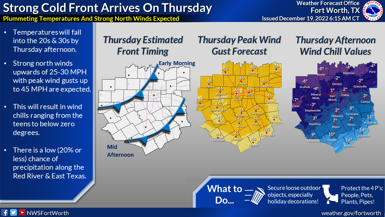
- The chance of any precipitation is low (20% or less), but cannot be ruled out along the Red River and into Northeast Texas on Thursday. Light rain may mix with snow, potentially transitioning to all snow before coming to an end Thursday afternoon. Impacts to travel are not expected.
Areas of Concern and Impacts


What We Are Certain Of:
- Subfreezing temperatures are expected to persist from Thursday through at least Christmas Eve, which will impact outdoor pipes.
- A strong cold front will arrive on Thursday with temperatures steadily falling into the 20s and 30s through the day.
- Strong north winds will accompany the front. Sustained winds upwards of 25-30 MPH with gusts in excess of 40 MPH are expected.
- Temperatures will fall into the teens and single digits Thursday night into Friday morning. Wind chill values will fall below zero.
What We Are Less Certain Of:
- Whether light precipitation (rain and/or snow) will accompany the front.
- Whether temperatures will rise above freezing on Saturday (Christmas Eve).
When will the next email update be sent?
- Tuesday by 10am.
Additional Resources
NWS Fort Worth Homepage http://www.weather.gov/
Hourly Forecasts (Click your location) https://www.weather.gov/
NWS Fort Worth Weather Tabs https://arcg.is/1S19nH
NWS Fort Worth Hazard Pages http://www.weather.gov/fwd/
NWSChat http://nwschat.weather.gov/
Who’s eligible for NWSChat https://nwschat.weather.gov/
NWS Fort Worth Briefing Page https://noaa.maps.arcgis.com/